Transforming Perspectives: The Role of 3D Modeling in Land Purchase Decisions
Empowering Informed Choices: The Benefits of 3D Modeling in Land Purchase Evaluations
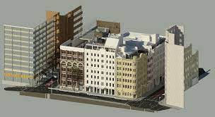
3D Modelling Derbyshire has revolutionized the way we perceive and evaluate land for potential purchase, offering immersive and detailed insights that enhance decision-making processes for buyers. By leveraging advanced technology and visualization techniques, 3D modeling allows prospective land buyers to explore and analyze key aspects of the property before making a commitment. This transformative approach not only saves time and resources but also empowers buyers to make informed and confident decisions.
3D modeling provides a realistic representation of the land, allowing buyers to visualize the terrain, topography, and features in a virtual environment. This level of detail enables buyers to assess factors such as slope gradients, elevation changes, water bodies, vegetation cover, and potential building sites with greater accuracy. By experiencing the land in a 3D format, buyers can gain a comprehensive understanding of its characteristics and envision how it aligns with their objectives and vision.
Moreover, 3D modeling enhances the due diligence process for land buyers. By integrating data from surveys, geographic information systems (GIS), and aerial imagery, 3D models can simulate various scenarios and analyze the impact of factors such as sun exposure, wind patterns, drainage systems, and land use regulations. This analytical approach helps buyers assess the feasibility of their plans, identify potential challenges, and explore opportunities for optimization or enhancement.
The adoption of 3D modeling in land purchase evaluations brings a myriad of benefits to buyers, including enhanced visualization, risk assessment, and strategic planning. One of the key advantages of 3D modeling is its ability to facilitate interactive and dynamic exploration of the land. Buyers can navigate the 3D model, zoom in on specific areas, and simulate different perspectives, gaining a comprehensive view of the property’s potential and limitations.
Furthermore, 3D modeling enables buyers to conduct virtual site visits and inspections, reducing the need for physical travel and site visits. This not only saves time and expenses but also allows buyers to explore multiple properties remotely and compare their attributes more efficiently. By virtually experiencing the land through 3D models, buyers can narrow down their options and focus on properties that best align with their criteria and preferences.
Additionally, 3D modeling supports collaborative decision-making among stakeholders involved in the land purchase process. Buyers, real estate agents, architects, engineers, and other professionals can collaborate within the 3D environment, exchanging ideas, sharing feedback, and evaluating design concepts in real time. This collaborative approach fosters transparency, communication, and alignment, leading to more informed and consensus-driven decisions.
In conclusion, 3D modeling has emerged as a game-changer in the land purchase landscape, empowering buyers with advanced visualization tools, data-driven analysis, and collaborative capabilities. By leveraging 3D models, buyers can gain a deeper understanding of the land, assess risks and opportunities, and make strategic choices that align with their objectives and aspirations. This transformative technology not only enhances the buying experience but also contributes to more informed and sustainable land development practices.